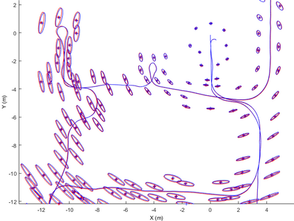
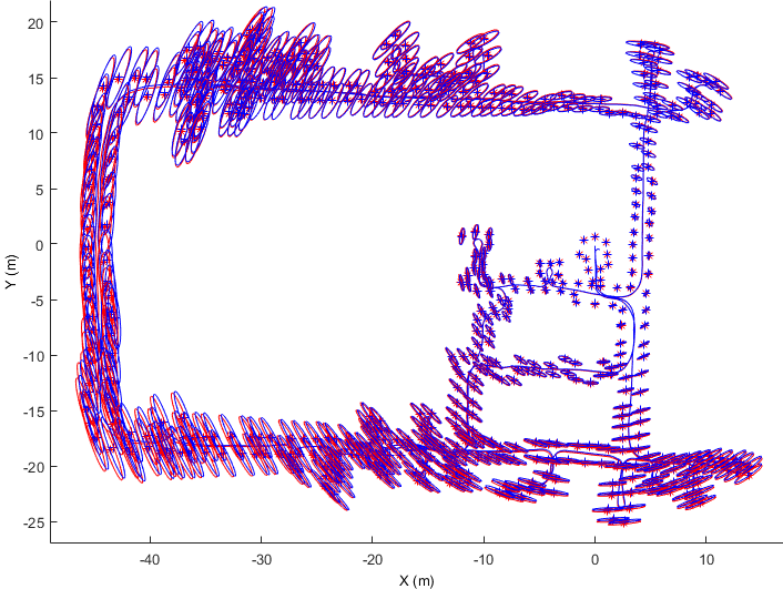
The main contribution of this paper is a new submap joining based approach for solving large-scale Simultaneous Localization and Mapping (SLAM) problems. Each local submap is independently built using the local information through solving a small-scale SLAM; the joining of submaps mainly involves solving linear least squares and performing nonlinear coordinate transformations. Through approximating the local submap information as the state estimate and its corresponding information matrix, judiciously selecting the submap coordinate frames, and approximating the joining of a large number of submaps by joining only two maps at a time, either sequentially or in a more efficient Divide and Conquer manner, the nonlinear optimization process involved in most of the existing submap joining approaches is avoided. Thus the proposed submap joining algorithm does not require initial guess or iterations since linear least squares problems have closed-form solutions. The proposed Linear SLAM technique is applicable to feature-based SLAM, pose graph SLAM and D-SLAM, in both two and three dimensions, and does not require any assumption on the character of the covariance matrices. Simulations and experiments are performed to evaluate the proposed Linear SLAM algorithm. Results using publicly available datasets in 2D and 3D show that Linear SLAM produces results that are very close to the best solutions that can be obtained using full nonlinear optimization algorithm started from an accurate initial guess. The C/C++ and MATLAB source codes of Linear SLAM are available on OpenSLAM.
翻译:本文的主要贡献是一个新的亚图合并法,用于解决大规模模拟本地化和绘图(SLAM)问题。每个本地子图都是利用当地信息,通过解决小规模的SLAM,独立地建立,通过解决小规模的SLAM;子图的合并主要涉及解决线性最小正方形和进行非线性协调转换。作为国家估计及其相应的信息矩阵,通过近似本地亚图信息,明智地选择子图坐标框架,通过在两个和三个层面同时加入两个地图,从而接近大量子图的合并。每个本地子图都是使用本地信息,无论是按顺序排列,还是以更高效的线性分解和征服方式独立地建立;大多数现有的子图合并方法所涉及的非线性优化程序是解决线性最小正方形最小方形的最小方形和非线性方形,因此拟议的子图合并不需要初步猜测,因为线性最小方形问题有封闭式解决方案。拟议的LISM技术适用于基于地标的SLM和D-SLAM,在两个层面,并且不需要在SLAMA初步的ALALM模型中进行任何精确的假设。